|
|
SmartExporter.DXF for ArcGIS/ArcMap:
| Product highlights: |
| Seamless integration in ArcGIS/ArcMap - adds a DXF export filter easily accessible through the ArcMap export dialog. |
| Creates well-formatted DXF files, which can be opened or imported in most CAD, GIS and drawing packages. |
| Complete support for all native ArcMap geo types, labels, layout elements, etc. |
| Export in paper and map coordinates with intelligent coordinate transformation and map rotation handling and no precision loss. |
| AutoCAD DXF layers used for splitting the exported objects in logical groups (e.g. data layers by name, labels, grids and graticules, etc.). |
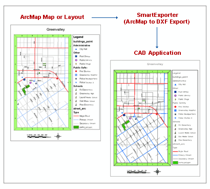
*real layout and real exported data displayed by
a third-party CAD/DXF/DWG application shown on this picture
|
 DXF2000 Support